Burnt Area
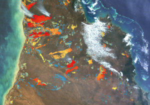
Fire is an important factor affecting vegetation globally. Wildland fires are a major contributor of greenhouse-gas emissions and threaten lives and infrastructure. In Australia between 200,000 and 800,000km2 land are affected by fire every year. Large and potentially catastrophic fires in southern Australia occur on a decadal time scale whereas fire-return intervals are between one and three years in the tropical savannas of northern Australia. Therefore there is a need for detailed, on-going, continental scale mapping of fire affected areas in Australia.
Consequently, maitec has developped and is operating a computer system that automatically maps fires in Australia up to twice a day using the MODIS sensors on the Terra and Aqua satellite platforms. The maps are usually available within 2h of the satellite overpass. Development is currently underway to utilise the VIIRS, OLCI and MSI instruments.